Capturing the Highest-Value Renewable Energy Resources
Apex’s internal GIS team maps the wind.
Since day one, Apex has prioritized investing in the experts and infrastructure necessary to bring renewable energy projects from idea to conception.
As the saying goes, it’s all in the details. For Apex, that means equipping itself with thousands of geographic information system (GIS) data sets that originate with more than 65 discrete government agencies, private vendors, and municipal sources, all of which are updated weekly, monthly, annually, or quinquennially.
But the thousands of data sets and millions—if not billions—of individual data points would be useless without a critical piece of the puzzle: the team behind the maps. Without those experts in place, the figures are simply static information.
“Many renewable energy developers outsource all geographic mapping work, but Apex’s internal GIS group is involved from project inception and enables the entire Apex team to visualize a project,” says Jess Cummings, senior GIS analyst at Apex. “Using our data sets and a growing library of records from Apex’s meteorological towers sited across nearly two dozen states, we can map anything from wind quality and market forecasts to transmission capacity and airspace restrictions.”
Even before Apex targets a greenfield site or acquires a project, the GIS team is sharing constantly updated intelligence with colleagues throughout the company to determine the best wind and solar resources from coast to coast.
“We can map a project earlier in the process and more often during development than many other companies are able to if they’re outsourcing this work,” says Cummings.
As things change and evolve at the project level, the Apex team can see the results immediately—rather than waiting days or weeks to fully understand the potential consequences. Ultimately, Apex benefits from a more intelligently and efficiently developed portfolio of projects.
Fine Tuning in the Field
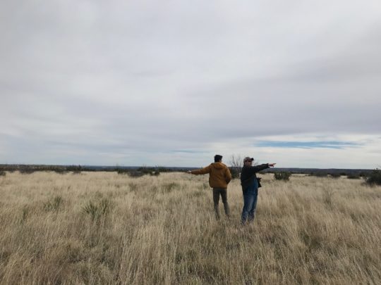
With millions of data points to track, it’s inevitable that a few bits of information from one of Apex’s sources won’t be up to date when the team needs its files to be 100 percent accurate. To ensure maximum precision as a project reaches the advanced development stage, the GIS team confirms its understanding of a project with micrositing trips.
That process of collaborative analysis continues over the years spent on a project’s development, and in real time. As commissioners in Illinois regulate turbine setbacks from roads, occupied structures, and property lines in their county, for instance, the GIS team can immediately determine the impact to an Apex project in that area.
Three to eight Apexers—usually a team member each from GIS, engineering, wind resource, and construction—traverse the site to verify every turbine location and ensure there aren’t any surprises that are digitally invisible.
“For instance, on a trip out to a Michigan project, we found the newly poured foundation of a house just steps from a proposed turbine site,” says Cummings. “Because we invested the time and energy to verify our data, we found the new construction and were able to take action to move the turbine and site it responsibly.”
Three years ago, Apex’s GIS analysts trekked project areas with paper maps, later inputting geo-tagged photos from their smartphones into the company’s digital mapping programs.
On today’s micrositing trips, analysts use an advanced GIS application to enter, edit, and update data in real time on their iPads. On-site at a wind project in Kansas, Cummings can upload photos of a potential turbine site, and instantly, the project developer can vet the information from more than 1,000 miles away at the company’s Charlottesville headquarters.
That immediate and all-encompassing ability to access and interact with the data brings even more value to the work of the GIS team. As the real estate team signs parcels and developers pin down another met tower location, any individual can update the web platform to ensure the entire group has the most current understanding of a project.
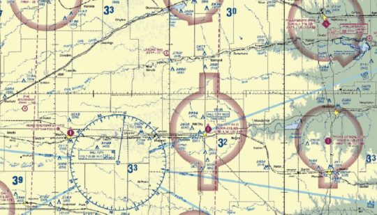
Sample layers from Apex’s proprietary mapping platform, ATLAS
Building a Proprietary Neural Network
Now that all of Apex’s 220 experts are able to interact with project data points, the GIS team can focus its energy on developing even more advantageous ways of utilizing the system—rather than simply maintaining it or sending out static maps that are outdated the moment they’re exported. The team is already mapping more than ten additional layers than it was just a year ago.
Future analysis will revolve around predictive modeling and will enable Apex to create a more robust portfolio of projects that carries less risk.
Over the past few years, as the team has collected and compiled data points on projects, it has also started storing and tracking that information.
“If a project’s fatal flaw—like a statewide wind moratorium—changes, by tracking that data, Apex can pick up precisely where it left off,” says Daniel Germroth, senior GIS application developer. “Even if it’s been a few years, the development manager can hit the ground running. And now, we’ve discovered that this information can provide valuable context for the rest of our portfolio, too.”
What began as an effort to understand what differentiates a successful project from a failed one is growing into a proprietary neural network.
“We collect data about successful projects as well as those that have failed, and with that information, we are training an algorithm to identify fatal flaws in other prospective locations,” says Germroth.
With the machine-learning algorithm in its infancy and continuing to evolve alongside the work of renewable energy developers, this next iteration of the Apex GIS team’s work will look vastly different from how it did even six months ago. Future analysis will revolve around predictive modeling and will enable the company to learn from an entire industry’s achievements and failures, creating a more robust portfolio of projects that carries less risk.
As the renewable energy industry has grown, and subsequently much of the low-hanging fruit in terms of projects has been picked, the GIS team is more valuable than ever before. Development companies are forced to take more creative approaches to siting projects, and Apex’s GIS personnel empower the rest of the team to do so without impairing efficiency or increasing a project’s exposure.
For GIS, it truly is all in the details. Whether it’s the footprint of a new home noted on a micrositing trip or an overturned county-wide wind setback law, tracking and mapping these data points—large and small—positions Apex more competitively as a leading renewable energy company of the future.
Authors